The Big One
Research & Inquiry
Professor Jack Loveless is part of a national team of researchers dedicated to bolstering the Pacific Northwest’s ‘seismic resilience’
Published November 29, 2023
Smith professor and geoscientist Jack Loveless is a member of a prestigious team of leading researchers from 14 academic institutions around the United States conducting groundbreaking research for CRESCENT, a newly established cutting-edge research center studying Pacific Northwest earthquakes. The Cascadia Region Earthquake Center (CRESCENT) is the first of its kind in the nation to survey quakes at subduction zones—where one tectonic plate slides beneath another—and to strengthen earthquake preparedness in the Pacific Northwest and beyond. The University of Oregon is leading CRESCENT, which is supported by a five-year $15 million grant from the National Science Center. Loveless is the only geoscientist from a liberal arts college in the Northeast on the team studying the possible impacts of earthquakes along the Cascadia subduction zone, which has a recorded history of spurring large earthquakes. Only in the past few decades have scientists begun to realize the potentially devastating power of subduction zones. Research suggests that it’s only a matter of time before an epic Cascadia subduction-zone earthquake dramatically impacts a sizeable portion of the coastal Pacific Northwest. Here, Loveless discusses this ambitious effort to bolster the Pacific Northwest’s seismic resilience, and how his contribution to that effort begins with GPS.
What are the Cascadia Region Earthquake Science Center’s main goals?
The main goal of CRESCENT is to develop a deeper understanding of earthquakes and related processes in the Cascadia region, which spans northernmost California, Oregon, Washington, and southern British Columbia. The center will support interdisciplinary research, public outreach, workforce development, and coordination with various agencies so that we can better understand, communicate, and prepare for the hazards and risks posed by earthquakes in this region.
How did you get involved?
My research focuses on using information from GPS to figure out what’s happening on faults that could produce damaging earthquakes. Many of us use GPS every day—it’s a technology embedded in our phones that allows us to geotag photos and use turn-by- turn navigation—and high-precision versions of GPS instruments continuously track the motion of Earth’s surface. Using these observations of movement, we can infer where faults are coupled, or stuck together, allowing them to efficiently accumulate energy that may eventually be released catastrophically in an earthquake. I have carried out this research in several regions worldwide, including Japan, South America, and Cascadia. I was invited to join one of the research teams of CRESCENT to help develop models of fault coupling, with hopes of illuminating future locations of damaging earthquakes.
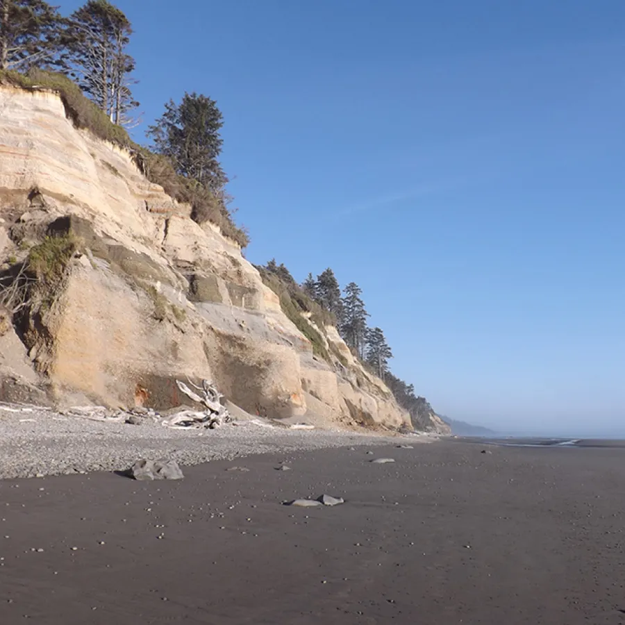
Geoscientist Jack Loveless is studying subduction zones in the Pacific Northwest. TOP IMAGE: A panoramic view of the Olympic Peninsula. "The cliffs indicate lifting up of the coastline due to earthquake-related processes," says Loveless.
The science is robust, and the work going forward is ambitious. Specifically, what is your role as you collaborate with other geoscientists, and what will be the focus of your research?
With a post-doctoral researcher to be based at Smith, I will help construct a model of fault coupling for the Cascadia region. We will work with scientists from Central Washington University, the University of Washington, the University of Oregon, and other institutions to analyze surface motion measured with GPS, small earthquakes detected with seismic stations, and episodes of “slow slip,” which is fault slip that releases some accumulated energy without producing shaking. By combining these observations with computer models, we aim to map out patterns of slip and coupling on the subduction zone. The goal is to develop these models in a modular fashion, so that as more data are gathered, and as new results from other groups associated with CRESCENT are shared, we can update the coupling model. The processes acting around the subduction zone are complex, and we hope that integrating discoveries made through CRESCENT research will provide clarity about earthquake hazards.
What is a subduction zone fault? How can we visualize what it is?
Subduction zones represent the contact between two tectonic plates that converge or move toward each other. As they converge, whichever plate is denser dives beneath the more buoyant plate, like vinegar and oil in salad dressing. I like to simulate subduction zones with my hands: as I move them steadily toward each other, then slide my left beneath my right, the fingertips of my right hand drag along the top of my left. My fingertips get stuck on my left knuckles, and I feel some strain or energy building in my finger muscles. This “hand straining” is what we see using GPS. Eventually, my fingers get tired, and I release the energy by sliding them past my knuckles, which represents an earthquake. Now imagine dabbing hand lotion on a few knuckles: some fingertips get stuck, and others slide easily. This variation in coupling is what we seek to map out, because the stickier knuckles are more likely to produce an earthquake.
Will this collaborative research endeavor be specific only to the Pacific Northwest? Or will it lead to new insights about earthquakes that can be applied elsewhere in the world?
While CRESCENT will focus on the Pacific Northwest, the research results will be transformative and can provide insight into earthquake hazards at other subduction zones around the world. The Cascadia Subduction Zone stands out globally as one that hasn’t produced a great earthquake for hundreds of years. The last one was a magnitude-9.0 earthquake in 1700, and it’s likely that a strong event will occur in the coming decades. Given the time since the last earthquake, much of the development of this region has taken place without first-hand experience, leaving communities ill-prepared for the next big one. The center’s focus on connecting cutting-edge science with workforce development, emergency response plans, and public policy agencies will hopefully allow new scientific discoveries to inform decision making and enhance resilience to earthquake hazards in the region.

